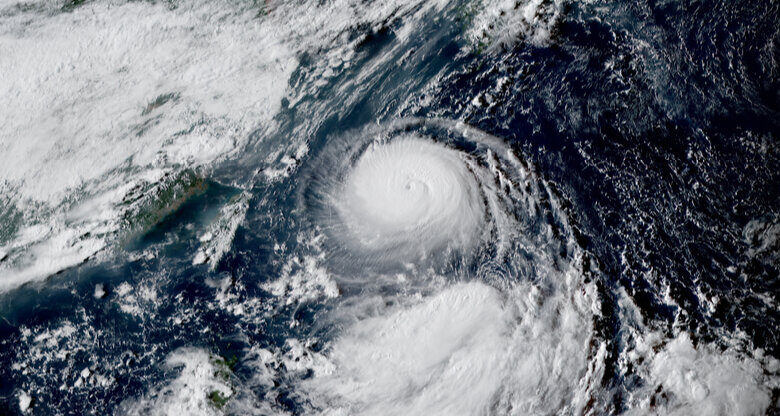
Typhoon Hinnamnor Brings High Winds to Japanese Islands

Typhoon Hinnamnor was bringing high winds to islands south of mainland Japan on Wednesday, a day after forecasters said it was the Northern Hemisphere’s strongest tropical cyclone of the year so far.
Hinnamnor was about 100 miles southeast of the Japanese island of Okinawa by Wednesday afternoon. It was moving westward through the Pacific Ocean at about 12 miles per hour, with sustained winds of 120 miles per hour and gusts of up to 172 miles per hour, according to the Japan Meteorological Agency.
An airport in the Daito Islands, southeast of Okinawa, recorded gusts of over 105 miles per hour, the Japanese broadcaster NHK reported on Wednesday. Weather officials in Japan warned that the storm could drop about seven inches of rain in the islands by Thursday morning, and potentially bring enough force to destroy homes.
The terms typhoon, hurricane and cyclone all refer to tropical cyclones; the term applied to a given storm depends on where it originates. Typhoons develop in the northwestern Pacific and usually affect Asia. Hurricanes form in the North Atlantic, the northeastern Pacific, the Caribbean Sea or the Gulf of Mexico.
In the Atlantic, major hurricanes — including Category 3, 4 and 5 storms — are defined as tropical cyclones with maximum sustained winds of 111 miles per hour or higher.
Government forecasts suggested on Wednesday that Hinnamnor, which formed in the Pacific on Sunday, would most likely dogleg right by Friday, avoiding Taiwan and mainland China’s southern coast, and head north toward the southern tip of the Korean Peninsula.
The links between tropical storms and climate change are becoming more apparent. Although warming might not lead to more such storms, researchers have found that it has increased the frequency of major ones because a warmer ocean provides more of the energy that fuels them.
Hinnamnor formed in the Pacific at the end of an unusually quiet month for Atlantic storms. The National Hurricane Center of the United States said on Tuesday that an area of low pressure moving westward through the Caribbean Sea could become the region’s fourth named storm of the season this week. It was not expected to reach the United States.
Hikari Hida contributed reporting.


